Posted in April 2015

Review: Building Mapping Applications with QGIS

It seems like over the last year the amount of literature published regarding QGIS has really exploded. In the past few months alone there’s been at least three titles I can think of (Building Mapping Applications with QGISMastering QGIS, and the QGIS Python Programming Cookbook). I think this is a great sign of a healthy project. Judging by this there’s certainly a lot of demand for quality guides and documentation for QGIS.

I recently finished reading one of these titles – Building Mapping Applications with QGIS. (Erik Westra, Packt Publishing 2015) In short, I’m a huge fan of this work and think it may be my favourite QGIS book to date! I’ve read Erik’s previous work, Python Geospatial Development, and thought it was an entertaining and really well written book. He’s clearly got an in-depth knowledge about what he’s writing about and this confidence comes through in his writing. So when I first saw this title announced I knew it would be a must-read for me.

In Building Mapping Applications with QGIS, Erik has created a comprehensive guide through all the steps required to create QGIS plugins and standalone Python applications which utilise the QGIS libraries. It’s not a beginner’s guide to Python or to PyQGIS, but that’s what helps it stand out. There’s no introductory chapters on programming with Python or how to use QGIS and instead Erik dives straight into the meat of this topic. I found this approach really refreshing, as I’m often frustrated when the first few chapters of an advanced work just cover the basics. Instead, Building Mapping Applications with QGIS is packed with lessons about, well, actually building mapping applications!

So, why do I like this book so much? Personally, I think it fills a a really crucial void in the existing QGIS literature. There’s a lot of works covering using QGIS, and a few covering PyQGIS development (eg, the PyQGIS Programmer’s Guide, which I reviewed here). But to date, there hasn’t been any literature that covers developing QGIS based applications in such great depth. It’s just icing on the cake that Erik’s writing is also so interesting and easy to read.

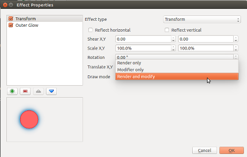
Is there any criticisms I have with this book? Well, there’s one small omission which I would have liked to see addressed. While the chapter Learning the QGIS Python API goes into some detail about how QGIS is built using the Qt libraries and a great deal of depth about interpreting the QGIS c++ APIs, I think it could really benefit from some discussion about both the PyQt and Qt APIs themselves. Since a lot of the QGIS classes are either directly derived from Qt classes or heavily utilise them it’s really important that PyQGIS developers are also directed to the PyQt and Qt APIs. For instance, the Qt QColor class is used heavily throughout PyQGIS, but you won’t find any API documentation on QColor in QGIS’ API. Instead, you need to first consult the PyQt API docs and also the detailed Qt c++ docs. It’s often that you may think the PyQGIS API is missing a crucial method, but consulting the Qt docs reveals that the method is instead implemented in the base classes. It’s an important point to note for mastering PyQGIS development. To be fair, I’m yet to read a PyQGIS book which has nailed the interaction between the QGIS, PyQt and Qt APIs.

Honestly, that’s a really minor quibble with an otherwise outstanding work. I’m so glad Erik’s written this work and strongly recommend it to anyone wanting to take their PyQGIS development skills to the next level.

Tagged , ,

Introducing QGIS live layer effects!

I’m pleased to announce that the crowdfunded work on layer effects for QGIS is now complete and available in the current development snapshots! Let’s dive in and explore how these effects work, and check out some of the results possible using them.

I’ll start with a simple polygon layer, with some nice plain styling:

Nice and boring polygon layer

A nice and boring polygon layer

If I open the properties for this layer and switch to the Style tab, there’s a new checkbox for “Draw effects“. Let’s enable that, and then click the little customise effects button to its right:

Enabling effects for the layer

Enabling effects for the layer

A new “Effects Properties” dialog opens:

Effects Properties dialog

Effects Properties dialog

You can see that currently the only effect listed is a “Source” effect. Source effects aren’t particularly exciting – all they do is draw the original layer unchanged. I’m going to change this to a “Blur” effect by clicking the “Effect type” combo box and selecting “Blur“:

Changing to a blur effect

Changing to a blur effect

If I apply the settings now, you’ll see that the polygon layer is now blurry. Now we’re getting somewhere!

Blurry polygons!

Blurry polygons!

Ok, so back to the Effects Properties dialog. Let’s try something a bit more advanced. Instead of just a single effect, it’s possible to chain multiple effects together to create different results. Let’s make a traditional drop shadow by adding a “Drop shadow” effect under the “Source” effect:

Setting up a drop shadow

Setting up a drop shadow

Effects are drawn top-down, so the drop shadow will appear below the source polygons:

Live drop shadows!

Live drop shadows!

Of course, if you really wanted, you could rearrange the effects so that the drop shadow effect is drawn above the source!..

Hmmmm

Hmmmm…

You can stack as many effects as you like. Here’s a purple inner glow over a source effect, with a drop shadow below everything:

Inner glow, source, drop shadow...

Inner glow, source, drop shadow…

Now it’s time to get a bit more creative… Let’s explore the “transform” effect. This effect allows you to apply all kinds of transformations to your layer, including scaling, shearing, rotation and translation:

The transform effect

The transform effect

Here’s what the layer looks like if I add a horizontally shearing transform effect above an outer glow effect:

Getting freaky...

Getting tricky…

Transforms can get really freaky. Here’s what happens if we apply a 180° rotation to a continents layer (with a subtle nod to xkcd):

Change your perspective on the world!

Change your perspective on the world!

Remember that all these effects are applied when the layers are rendered, so no modifications are made to the underlying data.

Now, there’s one last concept regarding effects which really blasts open what’s possible with them, and that’s “Draw modes“. You’ll notice that this combo box contains a number of choices, including “Render“, “Modify” and “Render and Modify“:

"Draw mode" options

“Draw mode” options

These draw modes control how effects are chained together. It’s easiest to demonstrate how draw modes work with an example, so this time I’ll start with a Transform effect over a Colorise effect. The transform effect is set to a 45° rotation, and the colorise effect set to convert to grayscale. To begin, I’ll set the transform effect to a draw mode of Render only:

The "Render only" draw mode

The “Render only” draw mode

In this mode, the results of the effect will be drawn but won’t be used to modify the underlying effects:

Rotation effect over the grayscale effect

Rotation effect over the grayscale effect

So what we have here is that the polygon is drawn rotated by 45° by the transform effect, and then underneath that there’s a grayscale copy of the original polygon drawn by the colorise effect. The results of the transform effect have been rendered, but they haven’t affected the underlying colorise effect.

If I instead set the Transform effect’s draw mode to “Modifier only” the results are quite different:

Rotation modifier for grayscale effect

Rotation modifier for grayscale effect

Now, the transform effect is rotating the polygon by 45° but the result is not rendered. Instead, it is passed on to the subsequent colorise effect, so that now the colorise effect draws a grayscale copy of the rotated polygon. Make sense? We could potentially chain a whole stack of modifier effects together to get some great results. Here’s a transform, blur, colorise, and drop shadow effect all chained together using modifier only draw modes:

A stack of modifier effects

A stack of modifier effects

The final draw mode, “Render and modify” both renders the effect and applies its result to underlying effects. It’s a combination of the two other modes. Using draw modes to customise the way effects chain is really powerful. Here’s a combination of effects which turn an otherwise flat star marker into something quite different:

Lots of effects!

Lots of effects!

The last thing I’d like to point out is that effects can be either applied to an entire layer, or to the individual symbol layers for features within a layer. Basically, the possibilities are almost endless! Python plugins can also extend this further by implementing additional effects.

All this work was funded through the 71 generous contributors who donated to the crowdfunding campaign. A big thank you goes out to you all whole made this work possible! I honestly believe that this feature takes QGIS’ cartographic possibilities to whole new levels, and I’m really excited to see the maps which come from it.

Lastly, there’s two other crowdfunding campaigns which are currently in progress. Lutra consulting is crowdfunding for a built in auto trace feature, and Radim’s campaign to extend the functionality of the QGIS GRASS plugin. Please check these out and contribute if you’re interested in their work and would like to see these changes land in QGIS.

Tagged , , , , , ,